

Your Better Drone Experience
Medium and Small Drone Specialist
Quadcopter Hexacopter Octacopter Fixed Wings
we integrate Tailor-Made aerial platforms
E-Mail to director@aerodrone.cl
USA WhatSapp & Mobile Contact +1 954 6043884 at Miami,Florida USA
CHILE WhatSapp & Mobile Contact +56 972120292 at Santiago, Chile


DRONES
PROFESIONALES
Desarrollamos Drones Multicopteros y Aviones para Aerofotogrametria, Mineria, Inspeccion,Agrimensura, Analisis Termal, Indices Agricolas, Filmacion, Reconocimiento, Busqueda, Agricultura de precision.
PROFESSIONAL
Daily Working Drones
We develop Multicopter Drones and Airplanes for Aerophotogrametry, Mining, Inspection, Surveying, Thermal Analysis, Agricultural Indices, Filming, Recognition, Search, Precision Agriculture.


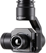
Camaras Termales , Multiespectrales,
RGB, Scanner Lidar, Magnetometros,
Camaras con Zoom, Object Tracking,
Vision Artificial, Deep neural network
Machine learning, Sensores de proximidad, Estabilizadores de Imagen
Servicio de Topografia LIDAR YellowScan

Thermal Cameras, Multispectral, RGB, Lidar Scanner, Magnetometers, Cameras with Zoom, Object Tracking, Artificial Vision, Deep neural network Machine learning, Proximity sensors, Image stabilizers Surveying Service LIDAR YellowScan
Autonomy / Coverage from 20km / 30 Ha up to 120 km / 1000 Hectares per flight
WE ATTEND ALL NORTH AND SOUTH AMERICA !
TIRED OF SPENDING WITHOUT RESULTS? , COME WITH EXPERTS !
Mouse Scroll Down

Autonomia/Cobertura desde 20km / 30 Ha hasta 120 km / 1000 Hectareas por vuelo

Built with the best components for U.A.V.s integration
Greater flight times and better weather resistance
Just define the Aircraft and Sensor that best suits your need
Construidos con los mejores componentes para integracion de U.A.V.s
Mayores tiempos de vuelo y mejor resistencia al clima
Solo defina la Aeronave y el Sensor que mas se ajuste a su necesidad
Artificial Intelligence Implementation of Deep Neural Network recognition algorithms
We implemented intelligent vision algorithms with TENSORFLOW / OPENCV / CAFFE under LINUX about company computers NVIDIA TX2 for Face Detection, Vehicle License Plates
Inteligencia Artificial Implementacion de algoritmos de reconocimiento Deep Neural Network
Implementamos algoritmos de vision inteligente con TENSORFLOW / OPENCV / CAFFE bajo LINUX
sobre computadoras de compañia NVIDIA TX2 para Deteccion de Rostros, Patentes de Vehiculos
Inteligencia artificial implementacion de algoritmos de reconocimiento deep neural network

Advanced courses in field operation
Normally Drones are loaded with instruments that cost several or tens of times the value of the DRONE itself, which is why an adequate training is very important to protect the instrumentation
Normalmente los Drones son cargados con Instrumentos que cuestan varias o decenas de veces el valor del propio DRONE, es por esto que una formacion adecuada es importantisima para proteger la instrumentacion
Cursos avanzados de operacion en terreno


Aerial Laser Scanning Service LIDAR RIEGL
The highest Technology in Scanner Lasser with 5 echoes and millimetric precision


Servicio de Scaneo Aereo Laser LIDAR RIEGL
La mas alta Tecnologia en Scanner Lasser con 5 ecos y precision milimetrica
Aerial Laser Scanning Service LIDAR RIEGL
The highest Technology in Scanner Lasser with 5 echoes and millimetric precision
Servicio de Scaneo Aereo Laser LIDAR RIEGL
La mas alta Tecnologia en Scanner Lasser con 5 ecos y precision milimetrica

Wide range of compatible stabilized sensors and sensors

The entire range of DJI cameras compatible with our DRONES
CLICK and GO !


Amplia gama de Sensores y Sensores estabilizados compatibles
Toda la Gama de Camaras DJI compatible con nuestros DRONES


Fixed Wing drone with a span of 3.5 meters, Up to 2.5 hours autonomy. Hybrid with vertical take-off for large-scale missions.
TitanE4Drone
The AIRCRAFT complements the tasks carried out by the Multicopters, improving the speed of taking pictures as well as the flight autonomy, prepared for high-end sensors and resolution, Maximun Instrument load 2.0 KG
2.5 hours of autonomy, Cruise of 90 km / h, Maximum 112 km / h, 300 km of range


.jpg)

AERHEX 1200PRO
HEXACOPTERO Professional Multifunction 55 MINUTES OF FLIGHT
Fly this Drone just like a DJI Phantom 4


Drone HEXACOPTERO for multiple use with 50 minutes of autonomy prepared for aerial photogrammetry, Camera with 30X Optical zoom, Thermal and Multispectral Analysis, Carbon Fiber Exoskeleton, high efficiency motors, detachable structure
Nuestros Partners


